-
Tropical Storm Nestor made landfall at the St Vincent nature reserve off Florida's northern Gulf Coast on Saturday afternoon.
-
 Tropical storm and storm surge warnings are in effect for the region.
 -
The investment manager, which is currently in run-off, is also monitoring the impact of Typhoon Hagibis.
-
AIG had $550mn of cover for Japanese losses, analysts at Credit Suisse noted.
-
The Bermudian reinsurer expects to pay out about $100mn in losses from Faxai and about $55mn for Dorian claims.
-
The Saddleridge fire has destroyed 17 structures and damaged a further 77 properties.
-
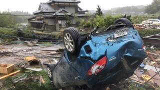
Gross cat losses for Japanese insurers this year could top 2018’s 1.6tn yen ($15bn) following Typhoon Hagibis, according to equity analysts Jefferies.
-
Saddleridge is one of several wildfires to have hit California in recent days, with nearly 160,000 acres and 134 structures destroyed.
-
The wildfire is threatening 13,000 homes and more than 100,000 people have evacuated.
-
The storm is now at Category 4 strength, and tracking to make landfall in Japan at Cat 3.
-
The provider said the losses were driven by the impact of Hurricane Dorian and Japanese typhoons.
-
Meanwhile, insured losses from Typhoon Faxai will approach $5bn, according to the September Global Catastrophe Recap.